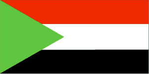
Country Guide • Sudan

Sudan is bordered by Egypt to the north, the Red Sea to the north east, Ethiopia and Eritrea to the east, Kenya, Uganda and the Democratic Republic of the Congo to the south, the Central African Republic and Chad to the west, and Libya to the north west.
| Official Name | Republic of the Sudan |
|---|---|
| Area | 2,505,813km² (967,500mile²) |
| Population | 38,114,000 |
| Continent | Africa |
| Population per mile² | 39 |
| Capital City | Khartoum, |
| Religions | 73% Sunni Muslims, 17% follow local native tribal beliefs, 8% Christians |
| Language | Arabic (official), Nubian, Ta Bedawie, diverse dialects of Nilotic, Nilo-Hamitic, Sudanic languages, English |
| Government | Authoritarian regime - ruling military junta took power in 1989; government is run by an alliance of the military and the National Congress Party (NCP), formerly the National Islamic Front (NIF), which espouses an Islamist platform |
| Currency | Dinar |
| GDP | $52.9 billion |
| GDP per Head | $1,420 |
| Natural Resources | Petroleum; small reserves of iron ore, copper, chromium ore, zinc, tungsten, mica, silver, gold, hydropower |
| Land Use | Arable Land 7% |
| Agriculture | Bananas, cotton, groundnuts (peanuts), sorghum, millet, wheat, gum arabic, sugarcane, cassava (tapioca), mangos, papaya, sweet potatoes, sesame; sheep, livestock |
| Industry | Oil, cotton ginning, textiles, cement, edible oils, sugar, soap distilling, shoes, petroleum refining, pharmaceuticals, armaments, automobile/light truck assembly |
| Tourism | Currently the British and Foreign Commonwealth Office state: 'Although peace talks are ongoing between the Government and the Sudan Peoples’ Liberation Movement/Army (SPLM/A), we advise against all travel to southern Sudan, except for those engaged in essential relief work. The military situation in the Eritrean border/Kassala area remains tense and uncertain. Darfur in Western Sudan remains a sensitive area although on 3 September the Government signed a 45-day cease-fire agreement with the Sudan Liberation Movement (SLM) of Darfur. Unless engaged in relief work, we advise against travel to these areas. But the vast majority of visits to Khartoum are trouble-free' |
| Natural Hazards | Dust storms and periodic persistent droughts |
| Health Risks | Malaria, HIV/AIDS, meningitis |
| Climate | Sudan's climate ranges from tropical to continental but much of the northern half of the country experiences a desert climate. The dry season ranges from three months in the humid tropical south to nine months in Khartoum with the hottest months July and August. Average annual rainfall varies from 6.3 inches to approx. 39 inches in Khartoum with most rainfall occurring between April and October. Average temperature ranges in Khartoum are from 15 to 32°C in January to 26 to 41°C in June |
| Time | GMT/UTC+2 hours |
| National Days | January 1 - Independence Day |
| Visas | British nationals should obtain a visa before travelling to Sudan. Before travelling to or around Sudan, check for the most current information from your embassy |
| British Embassy | Embassy Details |
Information Only
The content above is for information purposes only and we have tried to ensure that the information is as accurate as possible. We cannot accept any responsibility for any inconvenience, loss or injury as a result of the information above. You should always check and verify any critical information like visas, health and safety and customs with the relevant authorities before you travel since information can change at any time.


